
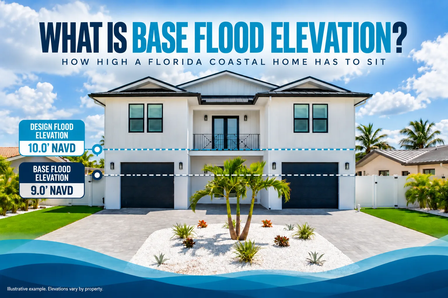
Base flood elevation (BFE) is the height that floodwater is expected to reach during a base flood, measured against a stated vertical reference point. The base flood is the flood that has a 1 percent chance of occurring in any given year, which is why it is often called the 100-year flood. FEMA publishes BFEs on its flood maps for certain mapped flood zones. For a homeowner, the BFE is the reference point that local floodplain rules use when they set how high a home must be built.
Key terms in this guide
- Base flood: the flood with a 1 percent chance of occurring in any given year.
- Base flood elevation (BFE): the height floodwater is expected to reach during that flood, at a specific location.
- Vertical datum: the agreed baseline an elevation is measured from. FEMA maps state which one they use, and older and newer maps may not use the same one, which is why a surveyor confirms it.
- Lowest floor: the floor used when comparing a building’s elevation against the BFE. How it is defined depends on the flood zone.
- Freeboard: additional height above the BFE, either required locally or chosen by the homeowner.
- Design flood elevation (DFE): the elevation actually used for design, which may be the BFE plus freeboard or other local requirements.
- Elevation certificate: a document recording a property’s measured elevations against the applicable flood elevation.
A few feet can make a significant difference when you are building a home in a flood-prone area. This is especially true in Florida’s coastal regions. The elevation of your home can affect the foundation, construction requirements, flood protection, and long-term costs.
For homeowners planning new construction or evaluating an existing property, knowing the property’s flood elevation can help avoid costly design and construction decisions later.
In this guide, we explain how BFE is determined, where to find it, what happens when a home sits below it, and why it matters when building a coastal home in Florida.
How Is Base Flood Elevation Determined?
Base flood elevation is determined through flood studies that examine how water moves through a specific area and how high floodwater is expected to rise during a base flood.
The process considers the physical characteristics of the area, including terrain, drainage, rivers, coastal conditions, and floodplain boundaries.
Floodplain Analysis
FEMA conducts flood studies to understand the likelihood, depth, and extent of flooding in different areas. These studies help establish the base flood elevations used for floodplain management and building decisions.
Hydrologic Analysis
Hydrologic analysis examines how much water enters a flood-prone area. Factors such as rainfall, watershed characteristics, drainage, and runoff are analyzed to estimate the amount of water associated with the base flood.
Hydraulic Analysis
Hydraulic analysis looks at how that water moves across the land. It considers channels, floodplains, terrain, structures, and other conditions that can affect the depth and movement of floodwater.
Flood Insurance Study and Flood Maps
The results of these analyses are documented in FEMA Flood Insurance Studies and used to develop Flood Insurance Rate Maps. Depending on the area and available data, the resulting flood elevations may be shown on the maps as contour lines, cross sections, or other mapped information.
Why Does Base Flood Elevation Matter?
BFE can affect how a property is evaluated for flood risk and how the home needs to be designed. For Florida homeowners, this information can guide decisions about home elevation, foundation design, floodplain construction, and other protective measures.
Helps Determine Home Elevation
Home elevation plays an important role in reducing flood exposure. Comparing the home’s elevation with the BFE shows how the structure sits in relation to the expected flood level. Key factors include:
- Height of the lowest floor.
- Expected floodwater depth.
- Required elevation for the property.
- Additional elevation above the BFE.
Influences Foundation Design
Flood conditions can affect the foundation selected for a coastal home. The foundation must support the home while also handling the conditions expected at the property. Important considerations include:
- Soil and site conditions.
- Flood depth and water movement.
- Foundation type and elevation.
- Structural loads and connections.
- Local construction requirements.
Supports Floodplain Building Decisions
Local floodplain requirements often reference FEMA flood data, and those requirements shape how an elevated coastal home is designed. They may cover:
- Minimum building elevation.
- Foundation design.
- Enclosed areas below elevated homes.
- Location of utilities and equipment.
- Flood-resistant construction measures.
Helps Assess Flood Risk
BFE helps homeowners compare their property’s elevation with the expected flood level. This comparison can show whether a home may need additional protection against floodwater. Homeowners can review:
- Existing ground elevation.
- Current home elevation.
- Property location within the floodplain.
- Difference between the home and BFE.
- Whether local freeboard requirements apply.
BFE vs. Ground Elevation: What’s the Difference?
A property’s ground elevation tells you how high the land sits, while BFE shows the expected elevation of floodwater during a base flood. Comparing the two shows the difference between the existing land level and the flood elevation used for planning and construction. Here is how the two compare:
| Factor | Base Flood Elevation (BFE) | Ground Elevation |
| Meaning | Expected elevation of floodwater during a base flood. | Height of the land at a specific location. |
| Purpose | Used to assess flood risk and guide certain building requirements. | Shows the existing height of the ground. |
| How it is determined | Based on flood studies and hydraulic analysis. | Determined through a land or property survey. |
| Property use | Helps determine how a home should be elevated in a flood-prone area. | Helps establish the existing elevation of the building site. |
| Relation to flooding | Represents the expected floodwater level. | Shows how high or low the property sits compared with the expected flood level. |
| Why it matters | Helps guide floodplain planning and construction decisions. | Helps show the elevation difference between the land and expected floodwater. |
How Does BFE Relate to Flood Zones?
The flood zone on a FEMA map tells you the level and type of flood risk at a property. BFE adds the missing detail: how high the water is expected to get. FEMA publishes a BFE for some mapped zones and not for others. In coastal Florida the common case is Zone AE, a high-risk area where FEMA has determined base flood elevations and shows them on the map. Where a BFE is published, building elevation requirements, flood-resistant construction requirements, and flood insurance requirements may all apply.
Coastal high-hazard zones, such as V and VE, measure differently again, and the requirements that come with them change how a home is designed. Our guide to building in a V zone covers what changes and why.
How to Find the Base Flood Elevation for Your Property
Step 1: Find Your Flood Zone and Map Panel
Start by locating the property on the current FEMA Flood Insurance Rate Map. Searching the property address shows the mapped flood zone, the map panel number, and the BFE where one has been established. Check that the address matches the correct property and that you are looking at the current effective map. Our guide to how to find your property’s flood zone walks through the lookup step by step.
Step 2: Review Your Elevation Certificate
If the property has an Elevation Certificate, review it for the recorded ground and building elevations. These measurements let you compare the property’s existing elevation with the applicable BFE. The certificate may show:
- Ground elevation.
- Lowest floor elevation.
- Building elevation.
- Flood zone.
- Vertical datum.
Step 3: Confirm the Elevation When Needed
FEMA map information may not provide a precise site elevation for every property. When accurate measurements are needed for construction or other property decisions, a qualified surveyor can determine the site’s elevation. Professional verification can be useful when:
- The property is near a flood zone boundary.
- Map information is difficult to interpret.
- Existing elevation records are unavailable.
- New construction requires accurate site measurements.
What Does a BFE Number Mean?
A BFE number shows the expected elevation of floodwater during a base flood at a specific location, measured from a vertical reference point. This is why homeowners should look at the BFE together with the property’s ground and building elevations.
The figures below are illustrative examples used to show how the comparison works. They are not elevations for any specific property. The BFE, required elevation, and freeboard that apply to a given lot depend on the effective flood map and local requirements, and Seasafe reviews those with you directly.
| BFE information | What it tells you |
| BFE of 10 feet | Expected base flood water-surface elevation is 10 feet above the stated datum. |
| Ground elevation of 7 feet | The land sits 3 feet below the BFE. |
| Ground elevation of 10 feet | The land is at the BFE. |
| Ground elevation of 12 feet | The land sits 2 feet above the BFE. |
| Lowest floor at 10 feet | The lowest floor is at the mapped BFE. |
| Lowest floor at 12 feet | The lowest floor is 2 feet above the mapped BFE. |
What Happens If a Home Is Below the BFE?
A home below the BFE sits lower than the elevation where the base flood is expected to reach. This can increase the home’s exposure to floodwater and affect several aspects of the property, from potential damage to building requirements and the placement of essential equipment.
Higher Risk of Flood Damage
A home below BFE can face greater exposure to floodwater during a base flood. Water may reach lower parts of the structure sooner, increasing the potential for damage to floors, walls, finishes, and other building components.
Impact on Building Requirements
New construction in a regulated floodplain may need to meet specific elevation standards. A home below the required elevation may need design changes to comply with applicable floodplain and building regulations. Our guide to building a flood-resistant coastal home covers what that involves.
Impact on the Home’s Lowest Floor
The lowest floor is especially important when comparing a home’s elevation with the BFE. If the lowest floor sits below the expected flood level, it can have greater exposure to floodwater during a base flood.
Potential Impact on Utilities and Equipment
Electrical systems, HVAC equipment, water heaters, and other essential components can be vulnerable when they are installed below the expected flood level. Their location may need to be adjusted to reduce flood exposure and meet applicable requirements.
Possible Impact on Flood Insurance
A home’s elevation relative to the BFE can be a factor when assessing flood risk and insurance. Other property characteristics, coverage details, and insurer requirements also affect the final cost and terms of a flood insurance policy.
What Is the Difference Between BFE and DFE?
BFE identifies the expected floodwater elevation during the base flood. The Design Flood Elevation, or DFE, can be used to establish a higher elevation for building design when additional elevation, freeboard, or local requirements apply. Understanding the difference helps homeowners avoid treating the BFE as the only elevation that matters. Here is how the two compare:
| Factor | Base Flood Elevation (BFE) | Design Flood Elevation (DFE) |
| Meaning | Expected elevation of floodwater during the base flood. | Elevation used for building design or regulation. |
| Purpose | Provides a reference for assessing flood risk and floodplain requirements. | Helps establish the required building elevation. |
| How It Is Determined | Based on flood studies and FEMA flood mapping. | May include BFE plus freeboard or other local requirements. |
| Relation to Floodwater | Represents the expected water-surface elevation of the base flood. | Can be higher than the BFE. |
| Use in Construction | Provides an elevation reference for floodplain construction. | Guides the elevation of the building and lowest floor. |
| Why It Matters | Helps show how the property’s elevation compares with the expected base flood level. | Helps meet applicable floodplain and design standards. |
What Is Freeboard and How Does It Relate to BFE?
The BFE is the starting point, not the answer. Most Florida communities require freeboard, meaning extra height above the base flood elevation. So what is freeboard? It is the additional vertical distance between the BFE and the elevation required or selected for a building.
How Much Freeboard Is Required?
One to two feet is common in Florida, and local rules can require more. Freeboard requirements are set locally and differ between jurisdictions, so the amount that applies depends on local regulations, flood zone, site conditions, and applicable building standards.
How Freeboard Is Measured
Freeboard is measured vertically from the BFE to the required or planned elevation of the building. For instance, if the BFE is 10 feet and a local requirement calls for 2 feet of freeboard, the design elevation for the home is 12 feet.
Why Freeboard Matters
Freeboard gives a home additional elevation above the mapped BFE. This can provide greater separation from expected floodwater. It may also help a structure meet higher local elevation requirements.
What Is an Elevation Certificate?
An Elevation Certificate records elevation information about a home and its property in relation to the applicable flood elevation. It can help homeowners understand how their structure sits within a flood-prone area, and it provides elevation data that may be needed for construction, floodplain compliance, or insurance purposes. An Elevation Certificate may include:
- Property location and flood zone.
- Ground elevation at the building site.
- Lowest floor elevation.
- Building and equipment elevations.
- Applicable vertical datum.
- FEMA flood map and panel information.
- Elevation information used to compare the structure with the BFE.
- How Does BFE Affect Flood Insurance?
The relationship between a home’s elevation and BFE can affect how its flood risk is evaluated for insurance purposes. The property’s elevation, flood zone, building characteristics, and coverage details can all be relevant. Flood insurance in high-risk areas is often written through the National Flood Insurance Program, and BFE can affect flood insurance by:
- Showing how the home’s elevation compares with the expected base flood level.
- Helping assess the property’s level of flood exposure.
- Providing elevation information used alongside an Elevation Certificate.
- Influencing how insurers evaluate the building’s flood risk.
- Helping identify whether the lowest floor is above or below the applicable BFE.
- Providing useful information when reviewing flood insurance requirements and coverage.
Can Base Flood Elevation Change?
Yes. A BFE can change when updated information leads to revised flood maps or flood studies. For homeowners, this means the elevation used for an older property or a previous project may not match the elevation shown on a newer effective map. A BFE may change because of:
- Updated flood studies and modeling.
- New information about rainfall, drainage, or water flow.
- Changes in terrain, channels, or floodplain conditions.
- Revised FEMA Flood Insurance Rate Maps.
- Updated data that changes the mapped extent or elevation of flood risk.
- Local or federal floodplain studies that provide more current information.
BFE vs. ABFE: What’s the Difference?
When updated flood studies point to changes in flood risk, homeowners may see advisory flood elevations before new maps become effective. The base flood elevation FEMA shows on an effective flood map is the established elevation for that mapped area. The Advisory Base Flood Elevation (ABFE) provides advisory elevation information based on updated flood data. Here is how the two compare:
| Factor | Base Flood Elevation (BFE) | Advisory Base Flood Elevation (ABFE) |
| Meaning | Established elevation of the base flood. | Advisory elevation based on updated flood data. |
| Map Status | Shown on an effective FEMA flood map. | May be provided before updated maps become effective. |
| Data Source | Based on the effective flood study and mapping. | Based on newer or updated flood study information. |
| Regulatory Status | Used as part of effective floodplain mapping. | Advisory and may not have the same regulatory status as an effective BFE. |
| Purpose | Provides the established flood elevation for the mapped area. | Provides information about potential updated flood elevations. |
| Planning Use | Used for applicable floodplain and building decisions. | Can help inform planning while updated flood maps are being developed. |
Why Does BFE Matter When Building a Coastal Home in Florida?
Building above base flood elevation can affect the home’s elevation, foundation design, and overall flood resilience. Reviewing the BFE early, before design work begins, gives the homeowner, builder, engineer, and surveyor a shared reference point to plan around. BFE matters when building a coastal home because it helps with:
- Setting the home’s elevation. Establishes a reference point for determining how high the living areas should be positioned.
- Planning the foundation. Helps guide decisions about elevated foundations and how the structure will be supported above expected flood levels.
- Meeting floodplain requirements. Provides an elevation reference for applicable FEMA and local building requirements.
- Reducing flood exposure. Additional elevation above the BFE can create greater separation between the home and expected floodwater.
- Protecting essential systems. Helps inform the placement of electrical equipment, HVAC systems, utilities, and other components that need protection from floodwater.
- Planning coastal construction. Allows the builder, engineer, surveyor, and homeowner to coordinate elevation requirements during the design stage.
Build Your Florida Coastal Home With Elevation in Mind
Knowing what base flood elevation is gives you a clearer picture of how flood levels can affect the way your home is planned and built. From the foundation and lowest floor to freeboard and local elevation rules, these details should be considered before construction starts.
At Seasafe Homes, we build elevated coastal homes along Florida’s Gulf Coast, with the state’s flood and coastal conditions in mind. Our team handles the details that go into the process, including site planning, engineering coordination, permitting, foundation work, and elevated home construction.
Elevation work is where the Two-Site Construction Model earns its keep. While the elevated foundation, pilings, and site work progress on your lot, the living space sections of the home are being built at our Offsite Build Center. The two tracks run at the same time rather than one after the other, which is how the schedule stays under tighter control even when a site needs significant elevation work.
Knowing the right questions to ask a coastal home builder before you start helps you understand your property’s elevation, flood zone, and construction requirements.
Talk to Seasafe Homes about your project and get the guidance you need to plan your coastal home properly from the start.
