
If you are buying, rebuilding, or planning a coastal home in Florida, your FEMA flood zone is one of the first things you need to understand.
It affects more than flood insurance.
- How high your home needs to be elevated
- What type of foundation may be required
- How the ground level can be used
- What local officials may require during permitting
- How insurance providers evaluate the property
- What your long-term cost of ownership may look like
For coastal homeowners in places like St. Pete Beach, Treasure Island, Madeira Beach, Indian Rocks Beach, Sarasota, Fort Myers, and other Gulf Coast communities, flood zone planning is not a side issue. It is one of the core parts of building correctly.
This guide explains FEMA flood zones, Base Flood Elevation, freeboard, flood maps, insurance considerations, and what homeowners should do before buying or building in a flood-prone area.
What Are FEMA Flood Zones?
FEMA flood zones are geographic areas that show the level and type of flood risk for a property. These zones appear on Flood Insurance Rate Maps, often called FIRMs.
FEMA uses these maps to help homeowners, lenders, insurance providers, builders, and local officials understand flood exposure.
The most important concept is the 1% annual chance flood, also called the base flood or 100-year flood. This does not mean flooding happens once every 100 years. It means there is a 1% chance of that level of flooding being equaled or exceeded in any given year.
For homeowners, the flood zone is a starting point. It helps identify risk, but it does not tell the full story by itself.
What Your FEMA Flood Zone Can Affect
Before buying or building in a coastal area, your flood zone should be reviewed early.
- Whether flood insurance is required by a lender
- How high the lowest living level must be elevated
- Whether pilings, reinforced masonry walls, or another foundation system may be needed
- Whether the ground level can be enclosed
- Whether breakaway walls may be required
- What documents are needed during permitting
- Whether a site-specific elevation certificate is needed
- How the home may be evaluated for long-term insurance risk
FEMA maps are important, but local code and site-specific review matter too. A property may require more elevation or additional design considerations based on the municipality.
That is why a flood zone review should happen before finalizing a plan, setting a budget, or comparing builders.
Common FEMA Flood Zones Homeowners Should Know
FEMA uses multiple flood zone designations. Some are more common in coastal Florida than others.
Zone AE
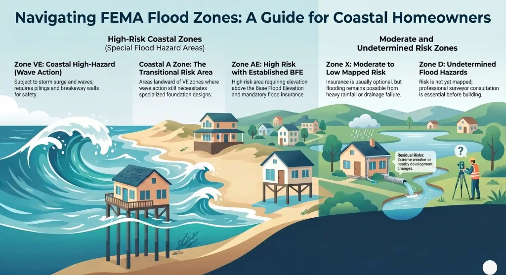
Zone AE is one of the most common high-risk flood zones. It means the property is in a Special Flood Hazard Area and has an established Base Flood Elevation.
For homeowners, Zone AE usually means:
- Flood insurance is commonly required if there is a federally backed mortgage
- The home may need to be elevated above the required flood level
- Foundation design matters
- Local freeboard requirements may apply
Zone AE is common in many Florida coastal communities.
Zone VE
Zone VE is a coastal high-hazard zone. These areas are subject to flood risk plus wave action during storm events. NOAA’s tide and water level data can be a helpful resource to learn more about the potential for storm surge, tidal flooding, or coastal water levels.
For homeowners, Zone VE usually means:
- Stronger foundation requirements may apply
- Pilings are often used
- Ground-level enclosures are more restricted
- Breakaway wall requirements may apply
- Construction and engineering review may be more complex
VE zones are especially important near open water, beachfront areas, and areas exposed to storm surge.
Coastal A Zone
Coastal A Zones are areas landward of a VE zone, or similar coastal areas, where wave action may still create higher risk than a typical inland flood area.
This zone matters because it can affect foundation design, ground floor planning, and how a municipality reviews the home.
Homeowners often overlook Coastal A because it may not sound as severe as VE. In practice, it still deserves careful review.
Zone X
Zone X is generally considered lower or moderate mapped flood risk, depending on whether it is shaded or unshaded.
A property in Zone X is not risk-free. Flooding can still happen from:
- Heavy rainfall
- Drainage failure
- Storm surge outside mapped limits
- Nearby development that changes water flow
- Hurricanes and extreme weather
Flood insurance may not be required by a lender in Zone X, but many homeowners still choose coverage.
Zone D
Zone D means flood risk has not been fully determined.
This does not mean the property is safe. It means more information is needed.
Before buying or building in Zone D, homeowners should consult local officials, a surveyor, and a qualified builder or engineer.
AE vs VE Flood Zones: Why the Difference Matters
For Florida coastal homeowners, AE and VE are two of the most important zones to understand.
Both indicate higher flood risk, but they are not the same.
Zone AE generally means the property has a known Base Flood Elevation. The main planning question is how high the home must be elevated and what foundation system makes sense for the site.
Zone VE includes coastal wave action. This usually creates stricter structural requirements.
The difference can affect:
- Foundation type
- Engineering cost
- Ground-level use
- Enclosure rules
- Breakaway wall requirements
- Insurance considerations
- Permitting review
A home in Zone VE may need a different structural solution than a similar home in Zone AE, even if the homes are only a short distance apart.
This is why broad online estimates are not enough. The lot must be reviewed.
What Is Base Flood Elevation?
Base Flood Elevation, or BFE, is the elevation that floodwater is expected to reach during the base flood event.
BFE is one of the most important numbers in coastal construction.
It helps determine:
- How high the home must be built
- Where the lowest living floor should be located
- How the ground level can be used
- How flood risk may be evaluated
- What elevation certificate information may be needed
If your property is in a high-risk zone like AE or VE, the BFE should be reviewed before designing the home.
What Is Freeboard?
Freeboard is additional elevation above the minimum required flood elevation.
For example, if the Base Flood Elevation is 10 feet and the local municipality requires 2 feet of freeboard, the home may need to be elevated higher than the FEMA minimum.
Freeboard matters because it can:
- Reduce flood risk
- Improve long-term resilience
- Support insurance review
- Help protect the home from future conditions
- Provide a safety margin above minimum requirements
Many Florida coastal municipalities require or encourage freeboard. This is one reason local code review is just as important as FEMA map review.
FEMA Is Not the Only Requirement
FEMA maps are a starting point. They are not the final answer for how your home must be built.
Local municipalities may require additional standards, including:
- Freeboard above BFE
- Site drainage review
- Setbacks
- Foundation requirements
- Ground floor limitations
- Breakaway wall details
- Documentation for permitting
In coastal areas like Pinellas County, St. Pete Beach, Madeira Beach, Treasure Island, Sarasota, and Fort Myers, local floodplain rules can significantly affect design and cost.
Before you rely on any online flood map, confirm the requirements with the local building department and your builder.
How to Find Your FEMA Flood Zone
You can start by using FEMA’s Flood Map Service Center. This is the official public source for flood hazard information produced for the National Flood Insurance Program.
Step 1: Search the property address
Enter the property address into FEMA’s map tool.
Review:
- Flood zone designation
- Nearby water bodies
- Whether the property appears in a Special Flood Hazard Area
- Whether BFE data is shown
Step 2: Compare with local records
FEMA maps may not include every local requirement. Check with the city or county building department for current floodplain rules.
Step 3: Get a professional review
Before purchasing or building, work with professionals who can review:
- Survey data
- Elevation certificate information
- Local freeboard requirements
- Foundation assumptions
- Permitting requirements
- A map is useful. A site-specific review is better.
What If the Flood Map Looks Wrong?
Sometimes a property is shown in a flood zone even though the land or structure may be above the mapped flood elevation.
In those cases, a homeowner may be able to request a map change from FEMA.
A Letter of Map Amendment, or LOMA, is a letter from FEMA stating that an existing structure or parcel on naturally high ground is not located in a Special Flood Hazard Area.
This process typically requires supporting elevation information. A licensed surveyor or engineer is often involved.
A LOMA is not something to assume. It must be reviewed and approved.
The Limits of FEMA Flood Maps
FEMA flood maps are useful, but they do not show every risk.
They may not fully capture:
- Local drainage problems
- Future sea level rise
- Recent development changes
- Stormwater backup
- Extreme rainfall events
- Nearby construction effects
- Erosion or changing coastal conditions
This does not mean the maps are not useful. It means they are one tool.
A smart coastal building decision uses FEMA maps, local code review, site-specific surveys, and experienced coastal construction planning together.
How Flood Zones Affect Cost and Timeline
Flood zones can affect cost before construction ever begins.
They may influence:
- Foundation type
- Piling depth
- Elevation height
- Engineering review
- Permitting timeline
- Ground-level design
- Stairs, access, and elevator planning
- Utility placement
- Insurance review
Two lots with similar views and similar home plans can have very different costs depending on flood zone, soil conditions, municipal requirements, and foundation design.
This is one reason Seasafe recommends reviewing the lot early. The flood zone is not just an insurance item. It affects the home design and construction plan.
How Seasafe Builds for Flood Zones
Seasafe Homes specializes in elevated coastal homes built for Florida’s flood-prone communities.
Our process begins with the lot.
Before moving too far into design, our team helps evaluate:
- The property location
- FEMA flood zone
- Base Flood Elevation
- Local freeboard requirements
- Likely foundation approach
- Ground floor use
- Municipality-specific requirements
Depending on the site, foundation options may include deep pilings, reinforced masonry walls, or other engineered systems based on soil conditions and local code.
The goal is to build the home around the real conditions of the property.
Seasafe also uses a Two-Site Construction model. While onsite foundation and ground floor work progresses, the home’s living space sections are built in a controlled Offsite Build Center. This helps reduce timeline risk and limits exposure to weather delays.
For homeowners, this creates a more predictable path from permit to completion.
Questions to Ask Before Buying or Building in a Flood Zone
Before buying land or starting design, ask these questions:
- What FEMA flood zone is the property in?
- What is the Base Flood Elevation?
- Does the municipality require freeboard?
- Is the property in AE, VE, Coastal A, or Zone X?
- What foundation system is likely needed?
- Can the ground level be enclosed?
- Are breakaway walls required?
- What will the elevation do to total project cost?
- How will the design affect insurance review?
- Has the lot been reviewed by a coastal builder?
These questions can prevent cost surprises later.
FAQ: FEMA Flood Zones and Coastal Homes
1. What does it mean if my property is in a FEMA flood zone?
It means FEMA has mapped a level of flood risk for your property. The designation may affect insurance, mortgage requirements, elevation standards, and construction planning. Make sure to verify your flood zone by searching the property address on FEMA’s Flood Map Service Center.
2. What is the difference between Zone AE and Zone VE?
Zone AE has established Base Flood Elevation data. Zone VE includes coastal high-hazard conditions with wave action, which can create stricter foundation and ground-floor design requirements.
3. What is a Coastal A Zone?
A Coastal A Zone is an area where wave action may still affect construction, even though the property may not be mapped as VE. It deserves careful review because it can influence foundation and design requirements.
4. What is Base Flood Elevation?
Base Flood Elevation is the expected height floodwater may reach during the 1% annual chance flood event. It helps determine how high a home should be built.
5. How high do I need to build in a flood zone?
That depends on the FEMA zone, Base Flood Elevation, local freeboard requirements, and municipal code. FEMA maps are the starting point, but local requirements often control the final answer.
6. Does FEMA determine my final building height?
Not by itself. FEMA provides flood map and elevation data, but local municipalities may require additional elevation or construction standards.
7. Is flood insurance required in Zone X?
Flood insurance is often not required by lenders in Zone X, but flooding can still happen. Many homeowners choose coverage even when it is optional.
8. Can I challenge my FEMA flood zone designation?
Yes, in some cases. A homeowner may request a LOMA if the property or structure is naturally above the mapped flood elevation and supporting documentation is provided.
9. Should I build above the minimum required elevation?
In many coastal areas, can provide added protection and a margin above minimum requirements. How a carrier evaluates a property depends on the policy and the insurer.
10. How does Seasafe help homeowners build in flood zones?
Seasafe helps homeowners evaluate the lot, flood zone, BFE, local elevation rules, foundation options, and ground floor use before moving too far into design or pricing.
Schedule a Lot Review
Flood zone information is only useful when it is connected to your specific property.
If you are buying, rebuilding, or planning a new coastal home, Seasafe Homes can help you review your lot and understand the best path forward.
Schedule a Lot Review with Seasafe Homes to begin.
